Sept. 10 (UPI) -- Hurricane Irma's eye headed toward southwest Florida's coast Sunday morning as a Category 4 storm, the National Hurricane Center said.
The NHC said in its 11 a.m. advisory the storm's center was about 80 miles south-southeast of Naples ad 115 miles south-southeast of Fort Myers. The storm had 130 mph wind speeds and was moving northwest at 9 mph.
Irma made landfall at Cudjoe Key in the lower Florida Keys at 9:10 a.m.
A hurricane warning was in effect for Fernandina Beach south around the Florida peninsula to Indian Pass, the Florida Keys, Lake Okeechobee, Florida Bay, Andros Island, Bimini, Grand Bahama and the Cuban provinces of Matanzas and La Habana. A hurricane watch was in effect for north of Fernandina Beach to Edisto Beach, S.C.
Storm surge warnings were in effect for South Santee River south to Jupiter Inlet, North Miami Beach south around the Florida peninsula to the Ochlockonee River, the Florida Keys and Tampa Bay.
A tropical storm warning was in effect for west of Indian Pass to the Okaloosa/Walton county line and north of Fernandina Beach to South Santee River. A tropical storm watch was in effect for Bimini and Grand Bahama.
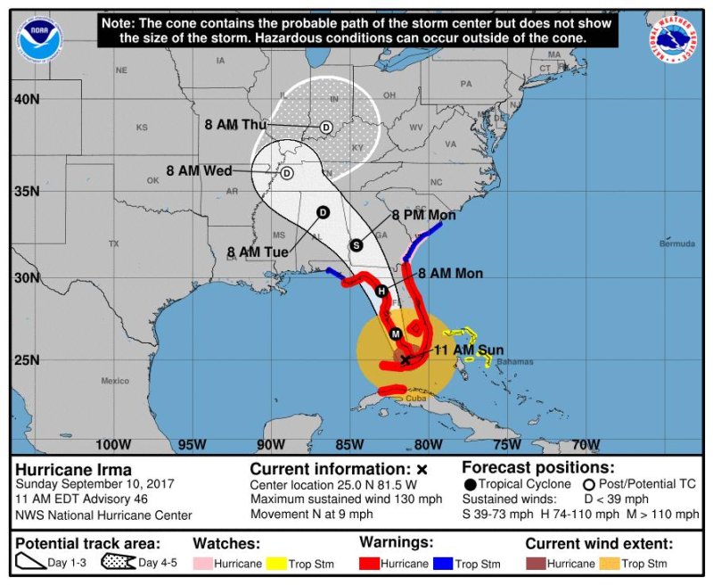
"On the forecast track, the eye of Irma should move over the Lower Florida Keys shortly, and then move near or over the west coast of the Florida Peninsula later today through tonight.," the NHC said.